
 The First Chamber in the Upstream Section
Three more years after the events described here and finally I had again the possibility to dive into this amazing cave; now it's time to realize a detailed cartography to fill in the blank of the whole Ko'ox Baal beautiful map produced by Czech team.
The goal is to realize a grade 4, class D map, according to the British Cave Research Association standards.
Based on the actual size of the cave,
I can estimate a duration of the project of about one and a half or two years.
A must: I have to thanks to my sponsors. They decided to support me with this challenging project; they know I have intention to bring the map, once completed, to the National Speleological Society saloon, where I already won two Honorable Mention ribbon for my previous works, Hol Kin and Minotauro maps.

Litterally a "ready to explore" harness; the most durable diving equipment I ever had, combined with the best performances.

Specialized in technical equipment for open and closed circuit diving, both in backmount and sidemount configuration
In addition to these two very important presences for my diving activity, I also extend my heartfelt thanks to the people who supported me in different ways: Henning Andrée, James Coke IV and Simon Richards.

Of course, realizing a detailed cartography is a complex work which requires dedication and time. I do this in my spare time, as a hobby, because I like it, but with the double goal to let everybody know the size and the direction of the acquifer, with the hope, one day, that the information included in my work could help the conservation of this unic, amazing and fragile environment.
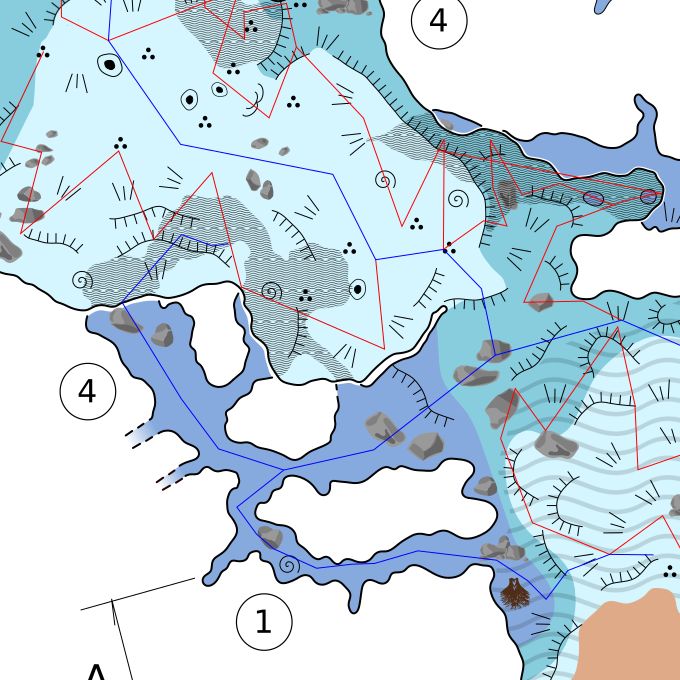
During the realization I decided to divide the map into two parts and publish the two sections, Upstream and Downstream, independently. One of the reasons was for the final layout, but also for the impatience to see a part of the project finished.
Passed under the careful eye examination of James G. Coke IV, experienced cartographer of both submerged and dry caves, which I thank publicly here, the upstream section can be said to be finished.
45 dives were required for a total of 115 hours and 41 minutes underwater
The map was presented at NSS Cartographic Salon 2021, where it received an Merit Award in the Experienced Category.

Fifty more dives into the downstream section, made in two years, to have another "tile" of the aquifer. The plan to divide the project into two distinct maps was applied once again, considering that there are two distinct branches of the siphon and that they run in two different directions, and I decided to dedicate a map to the East Downstream only.
This is a very beautiful section, running just on the northern side of a ridge; pushed by the flow of the upstream section, the water is diverted towards an anomalous direction by the compactness of the material that forms the ridge itself. Probably due to the reduced flow, the speleothems have retained their shiny surface, giving the impression, in some rooms, of being inside a glassware shop.
A total of 140 hours and 36 minutes underwater were necessary to recollect all the necessary datas for this map.
Both maps are available in different sizes and support; to pre-order send an e-mail.
Anyone can support the cartographic project by purchasing a shirt. Your help is very important.
Brands interested in sponsoring the project are welcome, they can contact me by e-mail.


| Number of dives since the project beginning | Number of hours underwater | Meters of reference line surveyed | Meters of new explorations |
| 95 | 256h 17' | 11634 | 3559 |